Trail number
Various fire trails - no numbering or identification. Please note this is a cinnamon fungus area so stay on the fire trails and wash bike before and after entering area.
Trail length
No set course length
Elevation variance
180 metres maximum elevation gain. Brisbane Ranges is on an escarpment so is relatively flat on the top and bottom but with steep climbs and drops from top to bottom.
Trail type
Largely fire trails ranging from good condition to poor. Some tending to single trail due to forest re-growth.
Trail surface
Smooth dirt, rocks and minor rock outcrops
Weather affected
Not overly affected by rain. This is a good option during wet weather when Wombat, etc are affected as the rain readily runs off the trails here.
Trail condition sources
Nil
Trail features
Fast drops, lung busting climbs, great views out over to You Yangs and of adjacent farmland.
Trail obstacles
Nothing major. Potential for small creek crossings. Be wary on hot or humid days - the climbs up the escarpment are pretty tough and out in the open.


Trail rating
Easy (on top of escarpment) to Intermediate
Rating basis
Estimated
Night riding
Yes
Family Friendly
Younger MTBers could readily ride this course as long as they have a reasonable level of riding confidence and stick to the top of the escarpment.
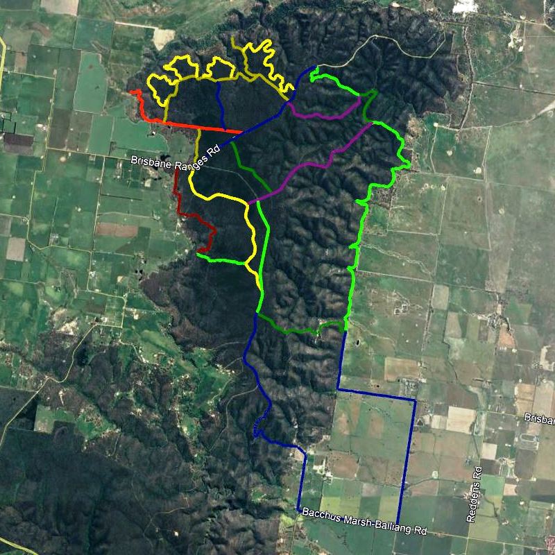
The picture above shows some of the main roads and fire trails in the area from a mash up of 7 gpx files. There are more trails in there over and above those shown above. Strava users can download gpx files from rides in the area along with segment information.
With reference to the satellite image above, the left half of the forest is relatively flat being the top of the escarpment whereas the right half drops rapidly from the escarpment down to the farmland below. The best place to park is up on the escarpment on Reids Road near Wattle Track or Red Ironbark Track. Two main loops can be accessed from there.
The yellow trails in the top left of the picture use Ridge Track as the backbone with three loop trails coming off it as shown. These are fire trails but are getting overgrown to the point where they are starting to approach single track in places. To the right of these loops is Aspera Track which is quite overgrown and is definitely approaching single track for the bulk of it. It does have a few prickly plants around so just work your way around them.
The other main loop is shown in the alternating light and dark green through the loop on the right hand side of the image. Wattle Track gives a direct run down the escarpment but Red Ironbark Track provides a much hairier ride on loose rock before hitting a creek crossing at the bottom - great fun. There is a slight climb up Aeroplane Track before a run down Brisbane Track to the farmland fence line. Brisbane Track meanders around the farm land with gentle rises and falls with great views out to the You Yangs over the farmland. There are a number of brutal climbs out from the fence line up the escarpment. The best one to take is Quarry Track which can be ridden if you've got the grunt to get up there - a real challenge and brutal in hot weather as it's very exposed so go early if hot weather is expected. Its a pleasant walk for a short way if not with views out over the old quarry and it typically has falcons or eagles soaring on the thermals in the area on the lookout for food.
Once back up on the escarpment, head over to Pea Track or some of the other trails before working your way back to the car. Thanks to Danny Halstead for identifying this area.
The area is a good option in wet weather as the trails hold up really well and shed water.
No video for this trail yet.
 |
Park on Reids Road near Wattle Track or Red Ironbark Track. This provides a good starting point. |
|---|---|
 |
No toilet facilities are available. |
 |
No drinking water is available. |
 |
No food or drinks are available in the immediate area. |
 |
No local information facilities are available. |